Elora and West Montrose by Bike
34 KM ROUND TRIP – 2 HOUR BIKE RIDE
START: Metcalfe St and High St Public Parking
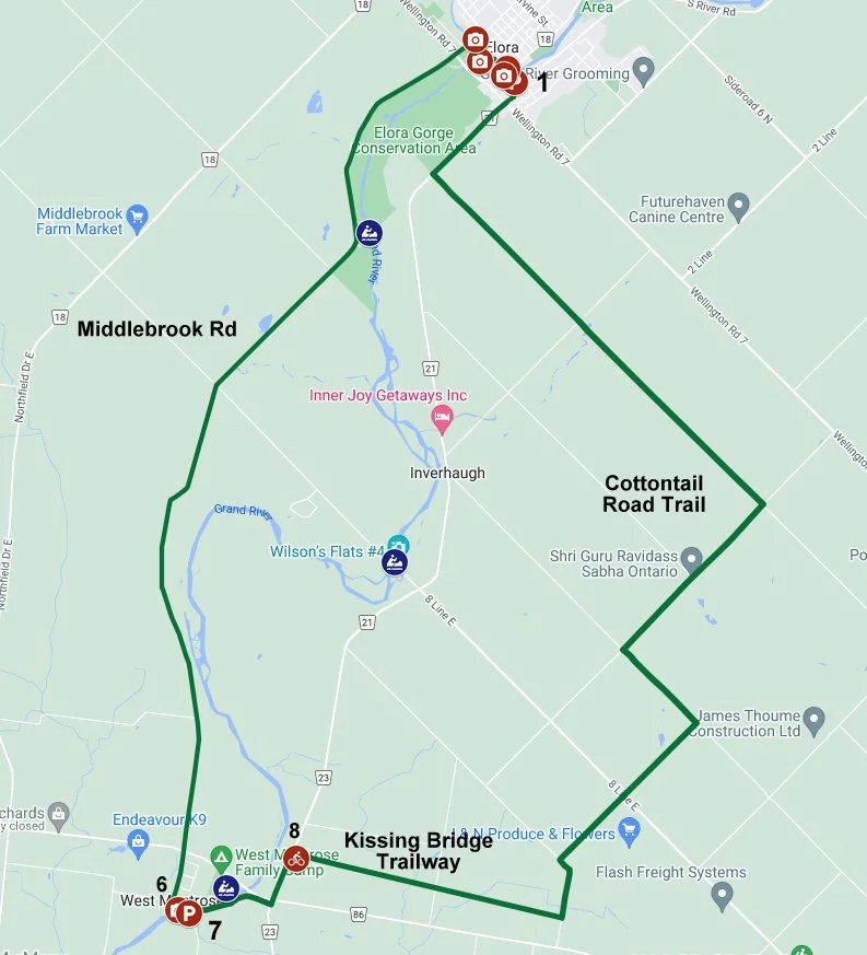
This bike ride starts in the picturesque village of Elora. Ride along a quiet country road to the West Montrose Covered Bridge, the only remaining covered bridge in Ontario. It is also known as the Kissing Bridge because it provided privacy to young people driving their buggies across the bridge. From West Montrose take the Kissing Bridge Trailway and the Cottontail Road Trail back to Elora.
This route in on-road cycling on paved and gravel roads, with two sections, totalling 2 km on busy highway.
Park at the public parking lot (1) at the cornier of Metcalfe St and High St in Elora. Alternatively, you can park at Letson Park (7) in West Montrose and start there.
From the parking lot, turn R and ride N on Metcalfe St. Cross the road at the lights before the bridge and walk over the Metcalfe St bridge for views of the limestone buildings on the banks of the Grand River. Walk up to the Elora Art Garden and Picnic Area (2) at the corner of Mill St W and Metcalfe St, and admire the Tall Man Sculpture. Hop on your bike and ride west along Mill St W towards the Elora Mill. Take time to walk onto the pedestrian bridge (3) (access on your left between the buildings) and take some photos of the Grand River and Elora Mill (don’t forget to share and tag @Grand_Trails on Instagram!). Turn right onto Price St, and then turn left onto James St and continue onto James Crescent. Take the trail to the left, which goes to a lookout (4) over the Grand River and Irvine Creek. After stopping to take photographs of the view of the Elora Gorge continue on the trail to David St W. Turn left and cross the David St Bridge over Irvine Creek (5), where there are great views of the gorge from the sidewalk on both sides of the bridge. Continue your ride along David St. Cross Wellington Rd 7 at the lights and continue on Middlebrook Rd (paved country road).
Ride along Middlebrook Rd passing numerous prosperous farms. Many have farm-gate sales (generally no Sunday sales) of local produce, maple syrup and Mennonite quilts. You may see local Mennonite residents using horse drawn ploughs or driving their buggies along the side of the road. Look out for the Middlebrook Castle on the right after Township Rd 60. As the story goes, a local farmer wanted to build an extra house on his property but was refused planning permission so he built himself a unique silo out of stone from his fields instead!
Just before Hwy 86, Middlebrook Rd crosses the Kissing Bridge Trailway, part of the Guelph to Goderich Rail Trail. The trailway detours into West Montrose as the railroad removed the bridge over the Grand River before returning the rail line to the public. However, you can ride to the edge of the Grand River to look at the view of the old bridge substructure and the river. Efforts are underway to replace the bridge and create a continuous trail to Goderich.
Cross Hwy 86 with caution. Then continue on Covered Bridge Dr to the West Montrose Covered Bridge (6). Take a break at Lost Acre Variety on the corner of Covered Bridge Dr and Hill St. Here you can buy snacks, including local baked goods and ice cream. Ride across the covered bridge to the picnic area at Letson Park (7) on Rivers Edge Drive on the other side of the bridge where you relax and eat your goodies. Take some photographs of the covered bridge (the best views are from Rivers Edge Drive). Then ride east on Rivers Edge Drive. Turn left when you reach Katherine St N (busy paved road). Cross Line 86 at the traffic lights and continue for 700 m to the Kissing Bridge Trailway (8) on your right. Descend the stairs with caution (use the narrow bicycle ramp in the middle of the stairs to walk your bicycle down.) To avoid the stairs, you can ride another 400 m up Katherine St N to Tribe Rd (gravel road) and turn right. Continue to Wollis Rd and turn right. After about 500 m, turn L onto the Kissing Bridge Trailway, which is now at the level of the road.
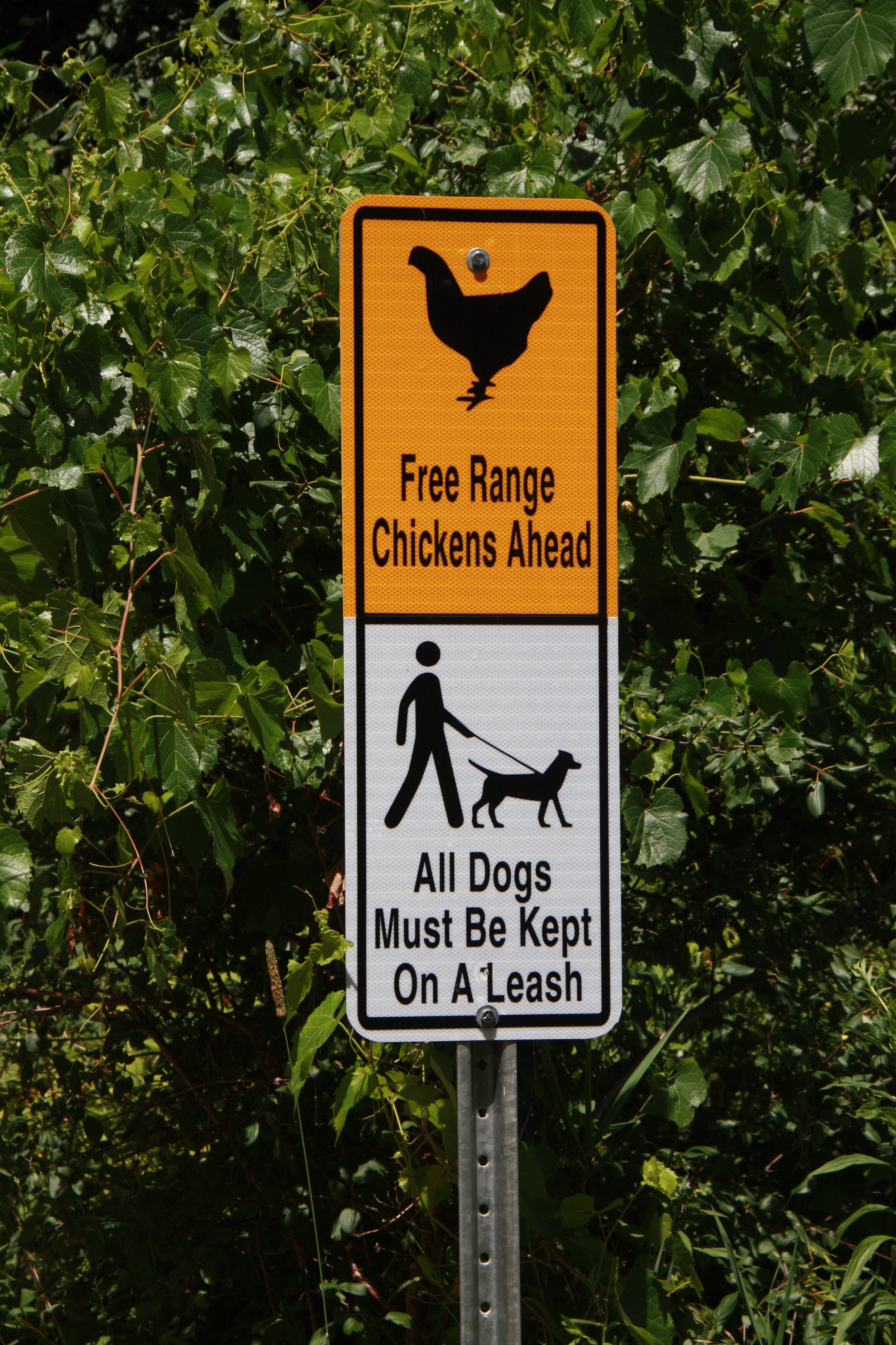
Ride along the Kissing Bridge Trailway past farmers’ fields. Turn left onto Weisenberg Rd (gravel road), which is the start of the Cottontail Road Trail After the bend in the road, turn right onto Side Road 12 (gravel road). Continue for 2 blocks until 6 Line E (paved country road) and turn L. Turn right at the next intersection onto Side Rd 10 (paved country road). Cross Side Rd 4, where 2 Line E is closed to traffic and becomes an off-road multi-use trail. Look out for the “free range chickens'' warning sign (and for the chickens)!
Continue on the Cottontail Road Trail to Wellington Rd 21 (very busy road with paved shoulders). Turn right and proceed with caution back to Elora. At Wellington Rd 7, continue straight onto MacNab St to the roundabout. Take the 3rd exit, which is Metcalfe St. Continue back to the parking lot at Metcalfe St and High St.
Now you can explore the shops on Mill St W and treat yourself to homemade ice cream. Save room for dinner at one of the amazing restaurants and pubs on Mill St and Metcalfe St.
If you have time for an exciting adventure, go tubing down the Grand River at the Elora Gorge Conservation Area (must be booked in advance) .
Free Range Chickens!
West Montrose Covered Bridge


